Bhengkek:Antarctica Without Ice Sheet.png
Bhengkek sokkla (782 × 1.000 piksel, okoran bhengkek: 675 KB, lambân MIME: image/png)

Bhengkek arèya asalla ḍâri Wikimedia Commons bân amè' èghuna'aghi bi' yèk-proyèk laèn. Jhâjhârbâ'ân ḍâri kaca jhâjhârbâ'ânna èdhudhuwaghi è bâbâ arèya.

Panotèng

Jhâjhârbâ'ân
Русский: Рельеф Антарктиды с учетом поднятия земной коры после таяния ледников и повышения уровня океана
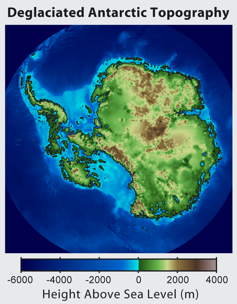
English: This is topographic map of Antarctica after removing the ice sheet and accounting for both isostatic rebound and sea level rise. Hence this map suggests what Antarctica may have looked like 35 million years ago, when the Earth was warm enough to prevent the formation of large-scale ice sheets in Antarctica.

Isostatic rebound is the result of the weight of the ice sheet depressing the land under it. After the ice is removed, the land will rise over a period of thousands of years by an amount approximately 1/3 as high as the ice sheet that was removed (because rock is 3 times as dense as ice). Approximately half the uplift occurs during the first two thousand years. If the ice sheet is removed over more than a few thousand years, then it is possible that a majority of the uplift will occur before the ice sheet fully disappears.

As indicated in the map, Antarctica consists of a large continental region (East Antarctica) and group of seas and smaller land regions (West Antarctica). Since the West Antarctic ice sheet is partially anchored below sea level, this region is less stable and more likely to be affected by global warming. Even so, it is likely that during the next century increased precipitation over Antarctica will offset melting.

Even in the event of severe sustained warming, it would take many thousands of years for Eastern Antarctica to be fully deglaciated.
Français : Carte topographique de l'Antarctique après avoir retirer la couche de glace et pris en compte le rebond isostatique ainsi que la montée du niveau de la mer Par conséquent cette carte montre ce à quoi l'Antarctique aurait pu ressembler il y a 35 millions d'années, quand la Terre était suffisament chause pour prévenir la formation d'une importante calotte glaciaire en Antarctique.

Le rebond isostatique est la conséquence de la couche de glace qui fait pression sur le sol et crée des dépressions. Après le retrait de la glace, le sol s'élève sur une période de milliers d'années par un rythme correspondant à un tiers de la hauteur de la couche de glace qui fut retirée (car la roche est trois fois plus dense que la glace). La moitié de l'élévation se fait pendant les deux premiers milliers d'années. Si la glace se retire sur une période dépassant plusieurs milliers d'année, il est possible que le rebond ait lieu avant que la couche de glace ne disparaisse complètement.

Comme montré sur la carte, l'Antarctique est composé d'une large région continentale (Antarctique oriental) et d'un groupe de mers et de petites régions terrestres (Antarctique occidental). Puisque la plaque glaciaire de l'Arctique occidental est en partie en dessous du niveau de la mer, cette région est moins stable et plus susceptible d'être affectée par le réchauffement climatique. En dépit de cela, des précipitation en Antarctique peuvent compenser la fonte. La fonte de l'Antarctique oriental prendra plusieurs milliers d'années, même en cas de réchauffement sévère et continu.
Tangghâl
Sombher http://www.globalwarmingart.com/wiki/File:Antarctica_Without_Ice_Sheet_png
Pangghâbây Image created by Robert A. Rohde / Global Warming Art
Versi lainnya File:Deglaciated Antarctic Topography.png – with no description (internationalized)

Lèlla

Robert A. Rohde, pemilik hak cipta dari karya ini, dengan ini menerbitkan berkas ini di bawah ketentuan berikut:
GNU head Èyèdhiyaghi nyalèn, nyalambheraghi bân/otabâ ngobâ ḍokumèn arèya kalabân rat-sarat Lèlla Ḍokumèntasi Bhibhâs GNU, Vèrsi 1.2 otabâ lebbi anyar sè èterbi'aghi bi' Free Software Foundation; tanpa Longkang Invarian, tanpa Tèks Sampul Aḍâ', bân tanpa Tèks Sampul Buḍi. Salènan lèlla èpamaso' ḍâ' ka longkang sè abhul-ombhul Lèlla Ḍokumèntasi Bhibhâs GNU.
w:id:Creative Commons
atribusi AbâgiMaghâs
Bhengkek arèya èlèlla'aghi bi' lèlla Creative Commons Atribusi-AbâgiSarobâ 3.0 Tanpa Adaptasi
Atribusi: Robert A. Rohde
Bâ'na ollè:
  • Abâgi – nyalèn bân nyalambheraghi polè matèri rèya ḍâlem robâ otabâ format apa bhâi;
  • mon ngobâ'â – ngarang, ngobâ, bân aghâbây toronan ḍâri matèri rèya
Aḍhâsaraghi katantowan arèya:
  • atribusi – Bâ'nâ kodhu aberri' pangakowan sè teppa', aberri' pranala ḍâ' lèlla-lèlla, bân aberri' tao mon bâḍâ obâ'ân. Bâ'na ngennèng alampa'aghi lèbât cara sè èkaterrowè bâ'na, tapè rèya ta' neptepaghi mon orèng sè aberri' lèlla makoko otabâ pangangghuyânna bâ'na.
  • AbâgiMaghâs – Menabi Dhika ngabhâstah, ngaobâ, otabâ aghâbây anot'aghi materi kamaksod, mèla Dhika kodhu madistribusi run-dhurrun Dhika dâ' pandhâp lisensi sè samè otabâ kompatibel samaghâs materi aslina.
Bâ'na ngennèng mèlè lisènsi pèlèanna bâ'na.

Captions

Add a one-line explanation of what this file represents

Items portrayed in this file

menggambarkan Indonesia

status hak cipta Indonesia

berhak cipta Indonesia

sejak Indonesia

10 Oktober 2012

tipe media Indonesia

image/png

checksum Inggris

589d868b4476f71d9a736899eaa4a5aa88b985e9

metode penentuan Indonesia: SHA-1 Indonesia

ukuran data Indonesia

690.846 Bita

tinggi Indonesia

1.000 piksel

lebar Indonesia

782 piksel

Riwayât bhengkek

Klik è tangghâl/bâkto mon nèngghuwâ bhengkek arèya ka bâjâ kasebbhut.

Tangghâl/BâktoMiniaturḌimènsiPangangghuyKomèntar
Taranyar16 Junè 2015 23.56Miniatur ghâbây vèrsi per 16 Junè 2015 23.56782 × 1.000 (675 KB)Szczureqlarger image
10 Oktober 2012 12.57Miniatur ghâbây vèrsi per 10 Oktober 2012 12.57469 × 600 (316 KB)Strannik27User created page with UploadWizard

Kaca arèya ngangghuy bhengkek rèya:

Pangangghuyân bhengkek global

Wiki sè laèn ngangghuy bhengkek arèya:

Mètadata